
We’re back from our 5 day backpacking trip to Grand Canyon National Park! This will be a two part post since there is so much to share! Check out our new trip video on Youtube and be check back or hit subscribe to see our upcoming gear post and video.
LETS GO!

TRIP DETAILS
LENGTH 43 trail miles
DIFFICULTY rated moderate to difficult due to elevation and trail conditions in a remote environment.
DATE HIKED March 5-9, 2023
MAIN FEATURES The Grand Canyon is on the traditional and contemporary homeland of 11 Indigenous tribes associated with the Canyon and surrounding area. You can learn about the cultural and spiritual significance of this sacred land, and more about the canyon’s native communities here.

This massive, breathtaking chasm in the earth was formed by the Colorado River and measures 277 miles long and up to 18 miles wide. It was designated as a National Park in 1919 and features many hiking and multi day trip options on the Park’s North and South Rims. Including the well-travelled corridor trail, as well as many lesser known remote trails within the canyon. Visitors can also enjoy day trips and a variety of amenities and educational opportunities in the Grand Canyon Village.
The North rim closes for the winter and the canyon is known for creating it’s own weather due to it’s mile-deep geological inversion. For more on park programming and features , know before you go tips and current conditions, please visit the National Park Website.

Our Itinerary
Here’s a quick snapshot of our itinerary including travel days and *campsites
- Fly in to Phoenix
- Phoenix-South Rim
- *South Kaibab-Phantom Ranch-Bright Angel
- *Bright Angel-Phantom Ranch-Cottonwood
- *Cottonwood-Clear Creek: Sumner Wash
- *Sumner Wash-Havasupai Garden
- *Havasupai Garden-Bright Angel Trail-South Rim
- South Rim-Phoenix-Home


Know Before You Go
This post will focus less on trip planning and logistics, and is more of a daily journal including noteworthy conditions and features that we enjoyed on our trip. I was lucky to join on an existing trip when a spot opened up. Our friend secured the permit months in advance and did most of the planning (which was pretty amazing – thanks Carrie!). This made trip planning easier on my part, but left a tighter window for training at 7 weeks. I’ll link some resources that we used at the bottom of this post.
Know trail conditions for your safety and the safety of others. We originally hoped to do a South Rim to North Rim to South Rim route and had two nights at Cottonwood Campground to do the up and back on the North Rim. But a couple of weeks before our trip, heavy snow fell on the North Rim, causing rockslides that damaged the trail, making it too dangerous for us to cross. Reaching the North rim was not as important as our safety, so we switched our permit with the backcountry office to add one night of camping off of the corridor trail- making for a really cool and unique experience. I’m so glad our group stayed flexible and found a plan b.
Read the fine print on your permit and check in at the backcountry office before you head out. We met a few backpackers that acquired their permit, but missed important details on food storage, safety and water sources. Do yourself (and the Rangers) a favor and build in the extra time to check in at the backcountry office before your trek to get the latest intel on trail conditions, requirements and make sure you have a safe and fun trip.
Foot traction and hydration. We can’t say it enough. WEAR FOOT TRACTION if it’s snowy/icy and bring plenty of water and electrolytes (even in the winter). I was surprised at how much water I drank and I know it helped me recover fully each day.
Save yourself carrying some food weight on your back and SPLURGE on the meals at Phantom Ranch. Meals need to be reserved in advance, and are a little more expensive – but totally worth it to have the cool experience of eating at this historic ranch, and the fact that everything is hauled up and down via mule train. I probably could have lived with eating my own lunch, but the full service breakfast and dinner were pretty amazing after a long day of hiking!

Phoenix to Grand Canyon National Park
We all flew into Phoenix and drove 3.5 hours to the Grand Canyon. It was interesting flying with all of our gear checked and making sure that we didn’t have any fuel, or other things that can’t go on a plane in our luggage. I bought an inexpensive duffel to put my backpack and a couple of days of clean clothes in to wear on the way home. The duffel worked great for keeping my bag and straps protected, but at 35 lbs, it was kind of a pain to lug around in addition to a carry-on day pack. Other members from our trip put their backpacks and gear in large suitcases with wheels, if you have one of those -definitely go that route.
We arrived at the South Rim in time for dinner, sunset and a stop at the Kolb Studio. Elk roaming everywhere. Back at the Maswik Lodge, we dumped out and re-sorted our gear. We made our decisions based on what the rangers at the backcountry office told us about weather, and honed our packs down the best we could to make the climb in and out easier on our bodies.
One of the hardest things about packing for our trip was the unpredictable winter storm that had closed roads prior to our trip and the drastic temperature difference from the top of the rim to the bottom. We just weren’t sure what to expect and I don’t like being cold. So I left a few pieces of winter gear in my bag and I was really glad I had them. I left my snow gaiters and extra puffy coat in the rental car, but used and wore everything else I brought.
My Artpack’s starting weight was 28.5 lbs including my standard gear, and 3L water, crampons and a 12oz. Ursack Almighty (I have the older white one with velcro) for our night of camping off of the corridor trail.

Day 1 | South Kaibab to Bright Angel & Phantom Ranch
There was still quite a bit of snow at the South Rim on our start day and the temperature was 24° with windchill. We arrived at the backcountry office by 7:45 to park the rental van and catch an 8am shuttle to the South Kaibab trailhead. If you are interested in seeing what your pack weighs before and after your trip, you can bring a luggage scale, or head into the office to weigh it on their big hanging scale. After a short bus ride, we took a few minutes to put on our crampons, double check our gear and were hiking down by 8:30.


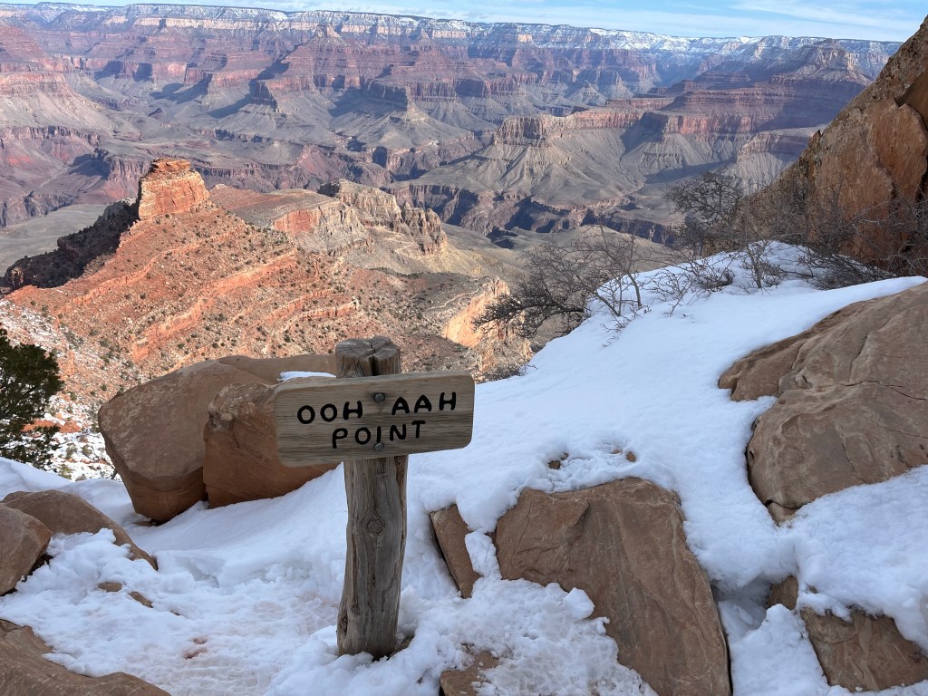
The trail was snow covered for the first 2 miles, but we felt safe in our spikes. The snow transitioned to a pinkish red, gooey mud + ice combo after a place called “ooh ahh point”. We naturally stopped and said “OOOOOH AHHH” emphatically a few times and took off our crampons at Cedar Ridge. FYI-Cedar Ridge had bathrooms and no water.


The trail remained muddy until just before skeleton point, where the environment seemed to instantly turn into a bone-dry desert, with cactus and ravens watching us closely for food (or maybe we were the food…and that’s why its called skeleton point!).


Stopped for lunch (my go to favorite-PBBH(f) Hiker Trash Tacos!) at a place called the Tip Off Point, where there was a nice shelter with benches and shade. Emergency non potable water, but did have bathrooms. My digital thermometer read 65° at noon, and the sun was starting to get hot.
After the Tip Off Point, there is a very steep hike to the Colorado river. My feet and knees were doing pretty good up to this point, but my pinky toes were feeling the pressure of going down. I remembered double heel lock/surgeon’s knot on my hiking boot laces and it helped. I normally wear trail runners, but switched to waterproof hiking boots for this trip due to rocks, and varying weather conditions and they served me well. No blisters- yay!


Seeing the river for the first time was amazing! It’s really hard to grasp the vastness and scale of this place. It just goes on and on and sometimes doesn’t even seem real. Changing geology…turquoise green colored shards underfoot…strong contrasts of red rocks and green shrubs- an artist’s dream!

We crossed the Black Bridge and arrived at Bright Angel Camp at 3pm. Right along Bright Angel Creek. Soaked my calves in the icy Bright Angel Creek, but it was so cold that we couldn’t stay in it for very long. This campsite was pretty cushy by backpacking standards with bathrooms, flush toilets, electrical outlet, a HAND DRYER and running water including a drinking water spigot. Each campsite also had tall racks to hang backpacks and food boxes to protect from rodents. NOTE: Super important to follow the NPS guidelines on storing food and guarding your pack at camp and on breaks- or you could end up with chew-holes in your pack or tent.
Luxuries are only a short walk away to Phantom Ranch…Mint tea and watercolor at 4pm, steak dinner at 5pm. We felt like queens! The Ranch has a small window that sells souvenirs, postcards, and snacks. Be sure to bring postage and send a postcard home with the special stamp that says “MAILED BY MULE AT THE BOTTOM OF THE GRAND CANYON PHANTOM RANCH”

A delicious dinner is served each night, family style. Steak, baked potato, real butter, sour cream, cornbread, roasted broccoli, fresh salad and a blondie brownie for dessert. We ate to our fill and I enjoyed more mint tea. It was a such a treat!! So glad we ate there and got to meet the wonderful staff and hikers.

I took a little mini bath in the bathroom and felt like a new woman! The temp was still 56° at 7:30pm. We planned for nights below freezing and were glad it was still so warm. My ‘shinankles’ and calves were sore and getting stiff from the long hike down, but the rest of my body felt great. Easier hiking tomorrow.

Day 2 | Bright Angel to Cottonwood
The day started with a mouth-watering breakfast at Phantom Ranch. Bacon, sausage, eggs, peaches, pancakes, orange juice, coffee and MORE mint tea! We also met some really cool people at our table and enjoyed hearing about their trips in the canyon.


Enjoyed one more cup of mint tea (I think I had 5 cups while I was there) and squeezed in time for a couple of quick watercolor sketches before hitting the trail. As a midwestern artist, I discovered how challenging painting the dramatic character of the Canyon and mountains can be. Oof. By the end of the trip, I started to get the hang of it, and learned that less is definitely more when trying to capture the beauty of this complex landscape.
Left camp 8:30. Ran into some guys who’s backpacks had been chewed by rodents. Yikes!


Today, we hiked through “the box”, a 4 mile long stretch in the canyon that is known for holding in heat and basically acting like an oven. When we started, it was 50 degrees, and it got up to 75 by the time we were out. I brought a tiny digital thermometer on the trip and it ended up being a pretty useful piece of gear since we were so curious about ‘real-time’ temps.
My least favorite section of the day was the exposed, stretch right after the box on the way to ribbon falls. We started hiking this section in the mid day sun, leaving me a little cranky and missing my beloved sunbrella. Fortunately, I had 2.5 liters of water and electrolytes in my body by then and a sun hoodie and long pants to keep me from burning to a crisp. Besides being a fair skinned redhead, you can read more about my experience with an annoying condition called Hiker’s Rash and why I generally avoid hiking in the heat in this post.
The bridge to Ribbon Falls is out, which led to 3-4 small water crossings that slowed us a little but were a nice way to cool off in the heat. I switched to my Crocs through the deep spots since I wore hiking boots on this trip. Had to do some route-finding to the falls but once we got there, it was like paradise!

The 100 ft waterfall pours down a crevice in the rocks (like a ribbon?) and has created this lush, green mossy monolith that feels like a mirage in a dry desert environment. It was so beautiful, and was a rare privilege to be able to enjoy it. The ice cold mist perked me up right away and was so cold we had to add a layer to stay warm. Hiked to the top of the waterfall, along the designated trail, and saw big animal prints that looked like a horse or MULE!
Ate my phantom ranch sack lunch at the falls. Bagel, cream cheese, strawberry jelly, apple, 2 meat sticks, peanuts, bar, electrolyte. Like I said, I probably could have just eaten my standard lunch of PBBH(f) aka Hiker Trash Tacos for one more day instead of buying one, but wanted to see what the lunch was like – and I ate ALL OF IT. Filtered 3L of ice cold clear water out of the falls and headed back to the corridor trail.

The trail kind of disappeared for a while and we ended up on either an animal or social trail after the water crossing, but found the trail again after a few minutes of re routing.


Another exposed, hot section into Cottonwood Campground. No ranger, no water (which we knew) did have an AED device. Water access to the creek is located behind the ranger station and amphitheater. Stayed at campsite 11 which is surrounded by scrub oak and a little more protected from the high winds that were expected overnight.
My digital thermometer says we had a temperature range between 38-98° today.
Beautiful sunset over the canyon tonight. Painted a little in my sketchbook by headlamp again. Calves are sore today but totally manageable. Feeling good. Slept great last night. A makeshift pillow between the knees helped with recovery and rolling calves out on a cork ball on the picnic bench.
Drank a warm lemon flavored electrolyte drink mixed with mint tea with dinner. I think I drank 4-5L today and the mint tea is really hitting the spot. It is my personal goal to eat ALL of the food I brought down so I don’t have to haul it back up. So far I’m on track with everything except one extra pro bar.
Hiker midnight struck early tonight. Bedtime started at 7, one by one, the backpackers head to their beds. Im staying up til 9 so I can sleep until 6.

Up next…Part 2: Days 3, 4 and 5 in the Canyon!
Read more about our night of “off corridor” camping under the full moon, sunset and a night hike at Plateau Point, Havasupai Garden and one more cup of mint tea at Phantom Ranch before heading back up to the top!
My artpack got a lot of love on this trip, and it was really great to get some red dirt on it and put it to the test. You can read more about my artpack in my last post here and look for an upcoming blog post and video that details out all of the gear I brought on this trip.
If you’d like to see more sketches and my tiny trail journal from the trip, you can check out a little instagram reel here and read more about my field art kit in this post.
Update: The trip video just published on my youtube channel. I have an upcoming gear video as well. Editing videos takes me a bit, so the best way to get updates is to subscribe to my channel and newsletter.
Resources
Planning a Grand Canyon Backcountry Hike or Trip
How I train for a Backpacking Trip
REI Backpacking Training Exercises- these were great training techniques for this trip.

This blog is supported by amazing readers, like you. Thank you!
Wait, how does that work?
When you buy the gear you need through our custom links, the companies listed here provide a small commission back to Wandering Pine at no additional cost to you. It’s an easy way to show your thanks for this free content, keep this site running and lets us know that you find value in the work we do and that is SO APPRECIATED! Thank you!
Wandering Pine is reader-supported and some of our blog posts may contain affiliate links. Learn more here.
Thank you for your support!
Well! That was fun! I can’t wait to read more and I can’t wait to talk to you and hear your your stories!
Thank you Crystal!! Im so glad you enjoyed it and can’t wait to catch up!