

How do you describe the beauty of a place where heaven and earth join seamlessly? Or the mind trap of telling yourself over and over again the this massive body is not the ocean or an endless sea? Or the magnetic-siren-pull of her waters that make you want to jump in and crash like the great ships full of men that lie beneath her waves? How, if you do dare to jump into her willing waters, and manage to come back up, you could feel reborn? Lake Superior is a magical sea that draws me and keeps me each time I visit her.
-Wandering Pine | May, 2018

Plan B
We’re back from our 5 day trip to Pictured Rocks National Lakeshore, affectionately known as our “Plan B Trip”. If you have been following along, you’ll know that I have had my eye on two wilderness trails within the North Country Trail and Boundary Waters Canoe and Wilderness Area in Northern Minnesota since 2019. Each year, I train for the Kekekabic and/or the Border Route, and each year there has been one of the following:
- 2020: Regional closure due to pandemic (Plague)
- 2021: Regional closure/warnings due to wildfire and drought (Fire)
- 2022: Hazardous/impassible conditions due to flooding (Flood)
- 2023: … (Pestilence? I mean the the mosquitos are pretty thick up there)
Each year, I mutter to myself in a quiet little voice…”The trail will be there, maybe next year?”
This year, we watched the reports closely, noting that there was still 17” of ice on nearby lakes 2-3 weeks before the trip, inaccessible trailheads, washed out trails and dangerous water crossings, 30-40 degree temps, more rain, and reports of people attempting hikes and turning back. The list of reasons not to go was growing daily.

Nope.
I had recently heard of Pictured Rocks National Lakeshore through friends. One week before our hike of “the Kek”, we finally realized we needed a plan B – and it all came together quickly!
This trip was one of the most beautiful and relaxing backpacking trips I’ve taken to date.

My feet and ankles are still feeling the small reminders of hiking for miles on sand. But the views are some of the finest that the midwest has to offer with a diversity that feels both foreign and like a familiar combination of so many other beautiful places I’ve been to. Many times on this trip, we wondered aloud:
Where… are we?
Let’s go!

TRIP DETAILS
LENGTH 42 miles on the North Country Trail along the shore of Lake Superior
DIFFICULTY Mostly flat elevation and easy to navigate, but could extend to moderate due to sandy/uneven hiking conditions and daily mileage.
DATE HIKED May 21-25, 2022
MAIN FEATURES Pictured Rocks National Lakeshore is located in a remote area of the Upper Peninsula of Michigan and was established as the first designated National Lakeshore in the United States in 1966. It is known for its layered bluffs, caves and arches, wilderness beaches and many other unique geological qualities that give the rocks a colorful, stained “painted or pictured” appearance. The park also features several waterfalls, Grand Sable Dunes and multiple access points to the trail, creating options for day hiking, backpacking and car camping.
Originally inhabited by the Anishinaabek and Ojibwe people, the beauty of this unique landscape has attracted explorers, fur traders, miners, loggers, and outdoor enthusiasts for generations and continues to be a treasure to be preserved.

Know Before You Go
There are over 100 miles of hiking trails in this park. 42 of them are on the North Country National Scenic Trail, the longest in the National Trails system at 4,800 miles long across 8 states. The 42 mile route covers the length of the park and follows the shoreline of Lake Superior with views of Grand Isle.
- Permit and Reservations are required. This is a popular park, but we saw fewer people by going early in the season.
- Many buildings and park amenities, including the visitor center are still closed before Memorial day.
- Lake Superior weather is ever-changing, be prepared.
- National Park brochure and backcountry maps were sufficient for navigation, but the Cliffs Campsite was difficult to find.
- Lake Superior water is COLD and the sandy cliffs are constantly eroding. Be aware, follow the park rules and use caution.
- Dogs are not allowed on wilderness trails and only in certain areas of the park- check the rules before bringing your pup.
- Bear boxes are provided at every camp and all trash must be packed out.
This trail is not to be rushed, take your time on this one, it’s a beaut!
Day 1: Munising Falls to Cliffs Group Campsite | 5.1 miles


After a 7-8 hour drive from Minneapolis, we met at the Munising trailhead at 4 PM and took a quick photo with friends before they drove my car to start their trip at Grand Sable. It was 47° and I forgot about the Time zone change and started an hour later than we planned. Stopped at Subway in Munising to grab dinner since it was a 5 mile hike in to the Cliffs Campsite and read that there was no water access.
- Water is plentiful this time of year and we passed several waterfalls and creeks on our way to camp. The closest reliable water access is Lake Superior, a couple of miles ahead.
- The spring ephemerals are in full bloom on the forest floor-Trout lilies, Trillium Dutchman‘s breeches, Jack in the pulpit…we stop and take photos, we are in no rush.
- The North Country Trail so far is in great condition with a few sections of mud. The trail is easy to follow along the shore of Lake Superior. No blazes, but NCT markers can be found at junctions.
- The trail is not well marked but it is well worn and easy to follow. Nevertheless, we missed the sign for our campsite tonight and found the group site about 1.5 miles away. We shared camp with a gal who thru hiked the Appalachian Trail – she backtracked and couldn’t find camp either, so we didn’t feel so bad.
- We suspect that there was a downed tree and/or the sign had been knocked down and reported it to the park trail maintenance staff we ran into on day 3.

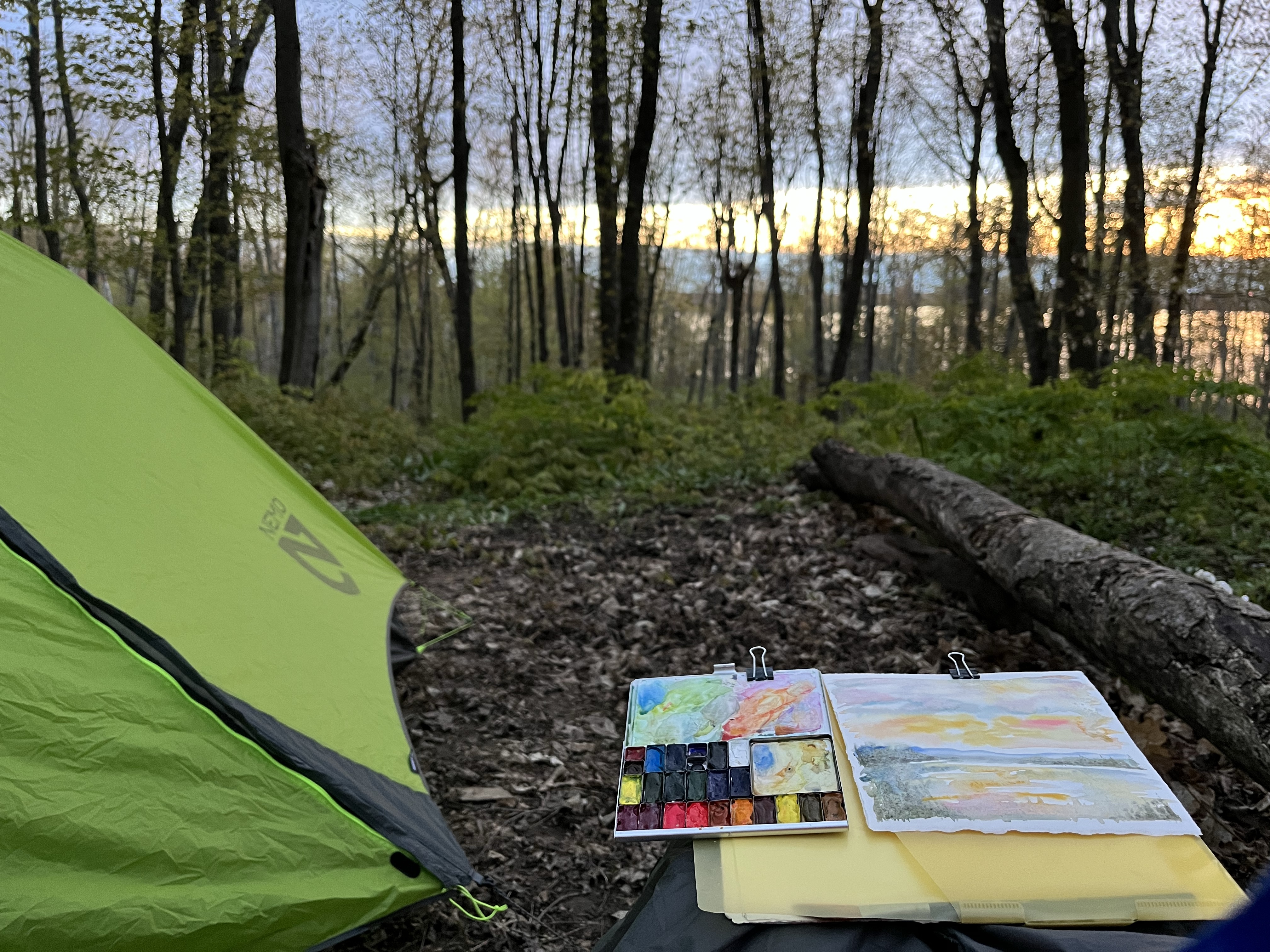
- My site overlooks the big lake and I enjoyed painting the fiery sunset. The sunsets arrive around 9:30 PM up here this time of year. The days are long and lingering, leaving us plenty of time to get wherever we want to go without rushing.
- Backcountry campsites are also on a reservation basis now which means that you don’t need to worry about getting a spot if you do end up rolling to camp late.
- after a long drive we are ready for bed. 38° and damp tonight. Glad I brought warm gear.
- all campsites have bear boxes and I was able to knock a little bit of weight off of my pack by packing everything in an odor-proof Opsack and leaving my Ursack Bear bag at home.
- Splurged and brought my new lightweight camp chair, and a few pieces of luxurious Arches French watercolor paper.
- had cell service at this campsite
- backcountry campsites are not easily located on existing GPS maps. Had we known this, we would have added the gps coordinates to our Garmin InReach before the trip

Day 2: Cliffs Group to Coves Campsite | 14.3 miles
Woke up to 33 degrees. Words cannot express the beauty and serenity of this place. Day 2 brought a big day of white sandy beaches and a zig zagging trail of overlooks. We lingered on this section of trail, marveling at its creation. We didn’t track our miles this day, but joked that it was probably a 20 miler with all of our side trips to the beach and peeping at every overlook.


- Chapel Rock
- Miners Island
- Grand Isle
- Tour boats
- Soft sandy trails
- Deep sandy trails
- Forests mysteriously growing out of white sand instead of soil.
- Mosquito River
- The Goat lost her kula cloth (We’ve both lost one on Michigan’s trails now)


BEACH DAY! We stayed at Chapel Beach for about an hour and a half for a long, lingering lunch break. Chapel Rock is a towering rock formation with a hole in the middle and a large tree growing out of the top. The tree has a long umbilical root that connects it to the mainland and has a trail access to get a closer look. I painted, dried out gear, soaked in the sun and sound of the waves and it was one of my favorite stops of the trip.

Our goal is to only drink filtered Lake Superior water on this trip, nothing out of creeks or streams. Only the finest, fancy pants water for us!
Day 3: Coves to Sevenmile Creek Campsite | 7.3 miles


9am visit from John (Skydiver Dude) and Taylor! These are our friends that we had originally planned on swapping cars with on the Kek and hiking in opposite directions. We were so glad that they were willing to switch to Plan B with us, so we could avoid shuttling or driving two cars to get back to the start.
It was great to hang out at out camp before they headed west. John hiked in a re-supply to my sister and I during our Superior Hiking Trail thru hike and nudged me to hike the trail sooner than later – thanks John, you continue to inspire me!
Today is a 7-8 mile day. I’m so glad were able to take our time on this trail there are just too many beautiful things to just breeze through it with high mile days. I painted a little at camp working on my chapel rock painting from yesterday
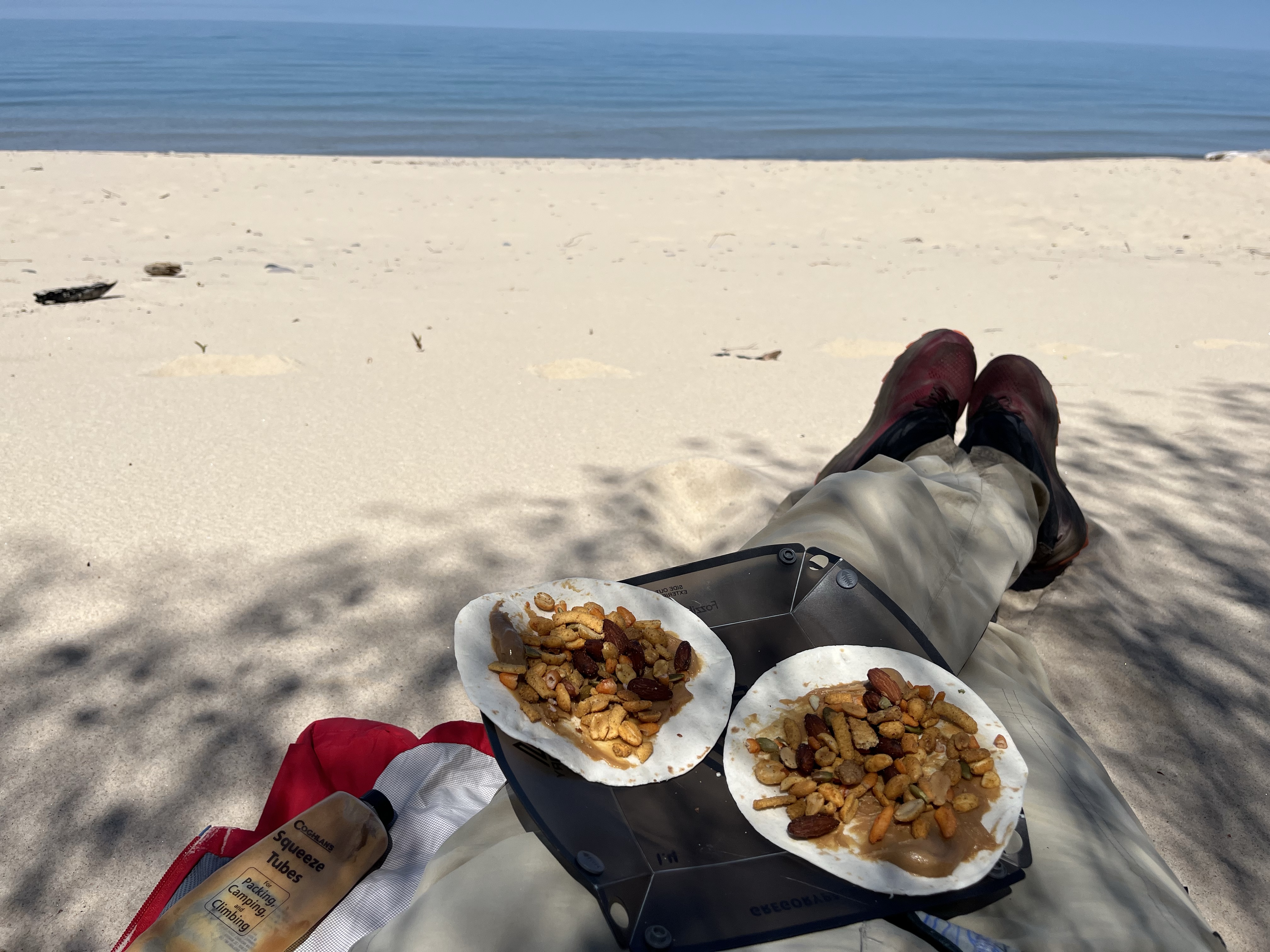
The beaches are now pure white sand and you can see out to the depths of the clear lake. Small round stones and familiar pine duff on the inland trails appear after pine bluff camp.

We got to 7 mile Creek camp around 4 PM and we’re very happy that this was our earliest evening into camp on this trip. We took our time setting up our campsites, and wandered around looking for the access to the beach. We only found a sketchy drop off/sand chute and decided to have dinner by the creek. We watched a couple of campers hike by us during dinner and figured they knew how to get down to the water – ah! An entry point was just a little further down the trail! We scooted down there in our campsites and had a lovely evening on the beach by the lake. I did a quick sketch of the creek and then a larger painting of the beach while we were there.
- The sun sets so late here it’s almost 9:30 or 10 before it gets dark plenty of time for long evenings but we are usually tired well before the sun goes down.
- We met a group of Minnesota campers that had a nice fire so we warmed up by the fire before we went to bed it’s been cold the last two nights and we been sleeping with our water filters to keep them from freezing.
- This campsite does not have a latrine but it does have a bear box. I got to use my brand spanking new poop shovel.
Stayed up until 9:30. Time for bed, with the sound of a creek rushing right by our tents. This place is amazing.
Day 4: Sevenmile Creek to Au Sable Point East | 7.3 miles


Breakfast at the beach, on trail by 10:30. Each day we stop for at least an hour at lunch and I paint while we dry out gear. This is some pretty relaxing hiking, no set schedule, we just wander along and are happy to get to camp as long as it’s before dark.
- We hit a few flat and fast hiking patches today
- Passed 12 mile campground. Really nice car camping no electricity
- 3 shipwrecks. Wandered up and down the coast but didn’t see any. Did see an iron top that had washed ashore by the Lighthouse
- The park is just opening for the season so the lighthouse looked like it had buildings you could go in and visit and learn more about the history but it was all still shuttered when we walked through.
- The entire shoreline changed again today-from rocky sandstone cliffs, to sandy beaches, to a few pebbles, then egg shaped rocks-to sandy variegated shoal. The ship graveyard: one mile deep of shallow stone that looks like wood grain.

The soft, sandy trails might get ya – I have four blisters – three on my toes and one on the ball of my foot. The sand is EVERYWHERE and impossible to avoid, I attributed the sensations to sand and didn’t realize I had blisters forming until it was too late. Glad I have a good blister kit with enough supplies to share.

Day 5: Au Sable Point East to Grand Sable | 7.3 miles
Out of camp by 8am, 7 mile Hike to the end. Approximately 5 miles of this section of trail follows along the grand sable dunes with steep slopes of ever-changing sand and a historic log slide used back in logging days. Today, visitors can take the long arduous journey up and down the slide, but caution must be used. There is a sign with the word caution on it SEVEN times (I counted) and a picture of an ambulance. It’s not the slide down that will get ya, it’s the long, slippery slog back up!


It was fascinating to read that with each degradation of the sand structure from people going down to the beach, the fierce lake winds blow the dunes up higher than they were to begin with and that the height of the dunes are actually increasing over time.
After the log slide, the North Country trail re-enters the woods through a lush green forest carpeted with Trillium and other spring ephemerals. The transition is surreal, noticing a forest floor covered with sand. We poked our hiking sticks at the sand and heard a crunchy layer of leaves beneath. There is white sand everywhere at this park including our shoes, gear, clothing and probably even our food.
Towards the end of the section, hikers will see a view of Grand Sable Lake and take a short road walk before re-entering the woods and finishing at Grande Sable visitor center.
And just like that, we were done. The beauty of this trail imprinted on our hearts and gifting us with sand in our shoes and gear that we’d still be dusting off back at home.


Lessons Learned
I enjoyed this trip most because of the amazing views, but more importantly, the shorter distances and time that we took to appreciate them. I’m thankful for my hiking buddy, ‘the Goat’, for making this a relaxing trip and so glad we didn’t push for long miles, or rush this route.
The sandy surface was a sneaky grind (literally) on the feet and we didn’t really feel the effects until day 3, with blisters and some sore shin and ankle muscles. Cold soaks in Lake Superior helped recover our feet, but there’s really no way to keep the sand out of your socks. All of that Hike Goo I like to slather on my feet might have made conditions worse, encouraging the sand to stick to my feet. Sand was definitely not covered in my Foot Care post.

Gear
I packed the same gear I used on last May’s Isle Royale Trip, and came in at 30 lbs with food and water. I subbed a new camp chair (super comfy!), smaller fuel can and brought some different art supplies. Overall, I’m happy with what I brought, knowing my body and Lake Superior temperature swings, but I woke up chilled each night despite warmer gear and being prepped for conditions. I’ll probably switch back to my wool base layers and bring a sleeping bag liner on my next Spring trip. Here’s a link to my Isle Royale packing list and video if you want to get a closer look.

I also ran out of stove fuel on my last night. I like coffee and oatmeal in the mornings, and hot dinner and tea at night, so this means I can’t get away with a small 4oz can on a 5 day trip. I have to bring a larger 8oz or plan on only boiling water in my 700 ml cup 5.95 times. 4 oz isn’t really a big deal to me, but I hate all of the leftover fuel that needs to get used up somehow. I wish they made a 6 oz can…that would be perfect!
Art Supplies
I typically bring a pretty dialed in Field Art Kit that you can read about here. I love my little moleskine journal and travel palette, but wanted to experiment with some Arches Watercolor paper wrapped in Tyvek and a larger dagger brush. Shoot me a note in the comments or at hello@wanderingpine.com if you would like to read more about painting and the supplies I used on this trip. It was so wonderful to have time to paint on the trail.

Food
I ate a combination of homemade and store bought dehydrated meals that were all pretty good. Check back for an upcoming post where I’ll share some favorite recipes and recommendations.
Have you been to Pictured Rocks National Lakeshore or visited Michigan’s Upper Peninsula? Its a gorgeous area and I can’t wait to go back!

For more photos from our trip and to read more about this summer’s upcoming adventures, check out the Wandering Pine Instagram and Facebook page and I’m still editing our video, should be up on my channel shortly. Check it out!
Happy Trails
~WP

Wandering Pine is reader-supported and some of our blog posts may contain affiliate links. Learn more here.
Thank you for your support!
Thank you for sharing your adventure. This has been on my wish list to do. Lots of great info. The scenery is spectacular. Really unique hiking experience for this region.
Thanks Pam. It was just one awe inspiring view after another. You have to see it to begin to comprehend its unique beauty!
Wonderful recap of your trip, Jen! Always a treat to travel/ read along with you, and fun to think a bunch of us were out exploring northern Michigan last week!
We thought of you many times on this trip and had hoped to crash your party in the Porkies, but the weather put a damper on things. I’m so glad to hear that you all had a fantastic adventure. Looking forward to hearing more and adventuring with you again soon!
Thank you for sharing your experience on this hike! The Pictured Rocks trail was our plan B this year too, as we had been planning on hiking the KEK this spring. We ended up on plan C though as we weren’t able to find an open campsite at Pictured Rocks for Saturday night of Memorial Day weekend. So we spent Memorial Day weekend at Sleeping Giant Provincial Park in Canada instead. Sleeping Giant was lovely, but reading your post makes me want to try for Pictured Rocks again next spring.
wow, so you know exactly what I’m talking about with the trail conditions on the KEK. One has to has themselves at some point, what kind of a trip it would be…with either dangerous or highly uncomfortable conditions. I’d love to know more about Sleeping Giant. Do you have a route you can recommend? Would be cool to head up that way!
Epic recap! Such a fun trip! Good reminder that chill trips are cool too!
Yes! Chill trips are cool, and I’m so glad we didn’t rush this one. Thanks for being willing to be flexible and make it happen!
Loved your post; Pictured Rocks is wonderful all year long (not as accessible by vehicle but I backcountry ski in to the lakeshore); I go there often as it is in my immediate area! You were lucky to get camp sites so late in the game. I know you had a key exchange deal with your cars but know that there is a shuttle you can also hire quite cheaply if you do it again.
Thanks Gail. Lucky you, to be so close! We did notice a little later that there was a shuttle, but it was still fun to still be able to hike with our friends. I think we may have gotten our reservations because its been a cold start to spring. Many of the backcountry sites that were booked to capacity were not full – I think people changed their minds when they saw the forecast. Happy trails!
Hi there! Your trip sounds like it was wonderful. I’m curious if these trails you were on are dog friendly? I’m planning a trip to hike the UP with my pup and am having trouble determining which trails are dog friendly and which ones are not. Thank you!
Hi Olivia, from what we could gather through signage, the trails at pictured rocks seem to allow dogs in front country campgrounds and near the trail heads, but do not allow them on the remote trail sections and backpacking sites. Definitely check ahead of time with the park to make sure you know which trails dogs are allowed on. Happy trails!