

As I am writing this, I have been working from home for over a month due to the Covid-19 pandemic. All State Park, Superior Hiking Trail and State Forest Campgrounds are closed until further notice in Minnesota and, on April 17th, the SHT issued an update recommending people continue to Hike In Place — meaning to explore the parks, trails, and neighborhood sidewalks close to home — and avoid traveling to the SHT. Some of that may have changed by the time you read this, so please make sure to check your state guidelines before venturing out and keep doing a good job of social distancing. We can all do our part and the trails can wait.
These days, where some of us find ourselves at home more than usual, are a great opportunity to work on organizing/thinning out/repairing your gear, readjusting trip plans, reading about a new adventure and brushing up on your skills. So when we can all go outside together again, we’re READY!
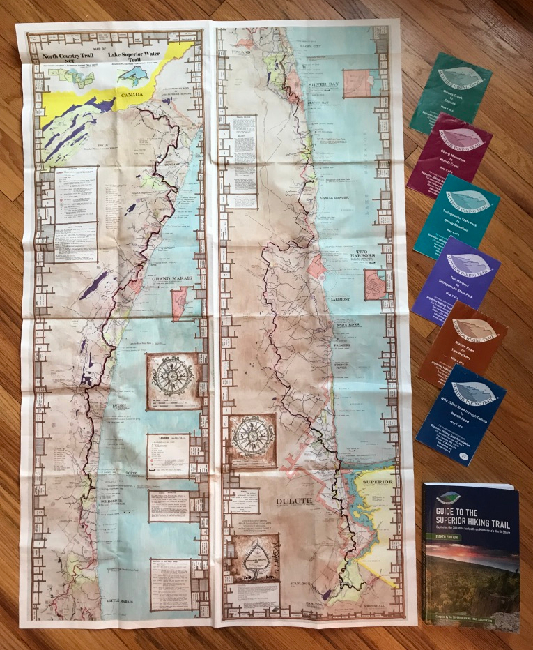
The Superior Hiking Trail sent me a copy of their brand new Databook to check out, and I dug right into it!


The Superior Hiking Trail Databook is a compact, easy-to-carry guide designed to help you explore the premier footpath along Minnesota’s North Shore of Lake Superior. This guide provides the most vital information you need to enjoy the Superior Hiking Trail.
- Detailed information for over 300 miles of trail, 94 backcountry campsites, and over 50 trailheads
- Accurate mile points between trailheads, campsites, water crossings,, trail road junctions, and more.
- Elevation profiles for the entire main trail.
- Compatible with southbound or northbound travel.
- Written for thru-hiker, backpacker, day hiker, trail runner, or occasional saunterer.
However you prefer to travel on the world-class Superior Hiking Trail, this Databook is your essential guide to exploring the rugged, challenging, and beloved footpath through the Northwoods of Minnesota.


This little gem is packed full of information! But the first thing I noticed is how small and compact it is. Even the lightest weight backpackers will find this easy to toss in their pack, weighing 3 oz. The 5x 7 size is also small enough to easily fit into a ziploc bag with your section maps.


Despite my fun-loving personality…I’m a rule follower. I like that this book starts right off the bat with a succinct review of the rules. This preserves and protects the trail for future hikers and answers many questions/discussions that I see come up in online conversations (like leashing pets and only camping in designated sites).


Mileage, elevation, distance between campsites and trailheads…it’s ALL IN HERE and organized by section, which makes it a great planning tool for all types of hikes! Colorful descriptions of natural features and campsites are not in this book, but the Guidebook still has that level of detail and is great info to know before you go. And this book makes it super easy to switch between Northbound and Southbound by either referring to the left or right side of the page. As I read through it, I kept thinking: “this little book would have been nice to have along on my hike”. I gave up trying to calculate exact mileage by the time I was on my last couple of sections of the trail. My brain just didn’t feel like doing math each time the itinerary changed and the notes I had made on my map were only as good as the original itinerary.
For a little context, here are the resources that I used to plan my trip. They are all still great for planning, but this little book consolidates much of the information that I was trying to piece together to bring on the trail.
Superior Hiking Trail Guidebook
Superior Hiking Trail Section Maps
Keith Myrmel Superior Hiking Trail Map
Mike Ward Superior Hiking Trail Distance Calculator
Mileage Charts on the Superior Hiking Trail Facebook page


- Campsite capacities are listed as (S,M,L) and have a few notes where hammocks may be an issue. If water is unavailable or unreliable at a campsite, it is noted and the closest water source is indicated. It’s also very easy to see the exact distance to your next campsite if you need to adjust your itinerary.
- Elevation is shown in 10 mile segments, mile by mile! Yay! This would have been helpful as I was planning my LASH and trying to balance effort and distance each day.
- Quick reference index in the back of the book lists: Campsite mileage, trailhead mileage and info like overnight parking and winter access.


- This little book is just about perfect, but I wondered why the Mileage index in the back of the book only lists Southbound mileage instead of including Northbound as well. This would be a helpful addition for hikers that are hiking Northbound or in sections that vary in direction.
- This may already be in the works, but this would be cool to have as an e-book for hikers that are already carrying an electronic reader on their hike (doesn’t replace your paper map, but it’s one less thing to carry)

Overall, I wish I’d had this handy little book on my SHT LASH and it will get tucked safely away in a ziploc bag with my section maps, ready for the next adventure as soon as the trail is safe for us all to enjoy again!
If you are planning a thru-hike, backpacking trip, day hike, trail run, or even an occasional saunter, this book is a handy resource. In addition to the planning resources I listed above. Two time SHT Thu-hiker and long distance hiker, Annie Nelson wrote a comprehensive e-book that is chock-full of “insider SHT thru hiker intel”, including food resupply resources, bear safety, search and rescue interviews and other essential tips. I was lucky enough to get to pre-read and edit her guide before it published, and recommend it as well!


If you are planning a trip on the SHT or just want to know more about his absolute gem of a trail, you can hear about my thru-hike, turned long awesome section hike (LASH) here! Day by day trip reports by section and the things I learned along the way can be found by hitting the Superior Hiking Trail tab above and on the Wandering Pine YouTube channel. I also tell the story of how my thru hike unfolded into a Long Amazing Section Hike on: Hike Podcast and will be a featured section hiker on the Hiking Radio Network – Jester Hikes podcast next month. Stay tuned!

Are you dreaming of hiking the SHT? Have questions about my trip? Hiking in your neighborhood while planning another big trip? I’d love to hear from you. Drop me a note in the comments or join the conversation on the Wandering Pine Facebook page.
Be safe out there…and Happy Trails!
~WP