

We’re back from our 5 day backpacking trip along the Border Route Trail! Normally I like to split longer reads into two posts, but wanted to get this trip report out in one long segment in case anyone is heading out there soon and needs up to date conditions. Our Youtube video and 15 lb baseweight Gear packing list just published, with lots of views and intel from the trail. Be sure to check back or hit subscribe for an upcoming post on food!
This trip has been in the works since 2019…the Border Route and the Kekekabic trails have eluded us due to pandemic closures, fire, flood, tornadoes and even injury! These trails are like that old 38 Special song…
“hold on loosely, but don’t let go, if you cling too tightly, you’re gonna lose control.”
The time was finally right, everything lined up and we went for it!
Lets go!


TRIP DETAILS
LENGTH 65 map miles (72 total GPS, including re-routes and spurs to campsites)
DIFFICULTY rated difficult due to elevation and remote, rugged trail conditions
DATE HIKED August 13-17, 2022
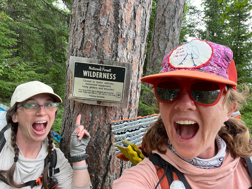
MAIN FEATURES The Border Route Trail is a 65 mile footpath that runs East to West along the Minnesota and Canada Border. It is known for its remote nature, panoramic views and deep wilderness environment. The trail traverses through the historic Gunflint Trail, Boundary Waters Canoe Area Wilderness, Superior National Forest and is part of the 800 mile Minnesota segment of the 4,600 mile long North Country Scenic Trail.

The Western Terminus connects to the Kekekabic Trail and the Eastern Terminus continues along the Northern Terminus of the Superior Hiking Trail. The trail is shared with wildlife including Moose, Black Bear, Wolves and the occasional Canoeist. Because the trail passes through the BWCAW, a permit is required before entry. There are a limited number of permits issued per day, so be sure to plan ahead. Reservations can be made online and picked up at the Grand Marais Ranger Station.


For navigation, we primarily used the BRTA maps and the BRT App, and supplemented with the Keith Myrmel BWCA Map and Earthmate GPS app that connects to our Garmin Inreach Satellite devices. I downloaded the Gaia and Avenza apps but did not use them. Note: It’s important to make sure to know how to use a map and compass before heading out on a wilderness trail, take a class and practice before heading out. We were lucky enough to be able to use technology, but brought the tools we needed to navigate without it as a back up.

Trail Segments and Conditions
The West end of the BRT starts at the Gunflint Trail Trailhead
- Approx. 3 mile hike to Magnetic Rock. The mineral properties in this 30 foot monolith will make your compass spin and is a fun place to stop and take a photo.
- The next few miles of the section past Gunflint Lake can be tricky to navigate as it shares ski and day hiking trails that feed into the many resorts in the area.
- The resorts mainly maintain this area, but the trails can become overgrown this time of year, so watch your footing and keep your eyes peeled.
- The Crab Lake area was the brushiest section and had a couple of spur trail signs.
- Blueberries, thimbleberries and raspberries were plentiful in this area and made for a great trail snack!
- This section has the most trail markers: blue blazes, flagging and North Country Trail signage.
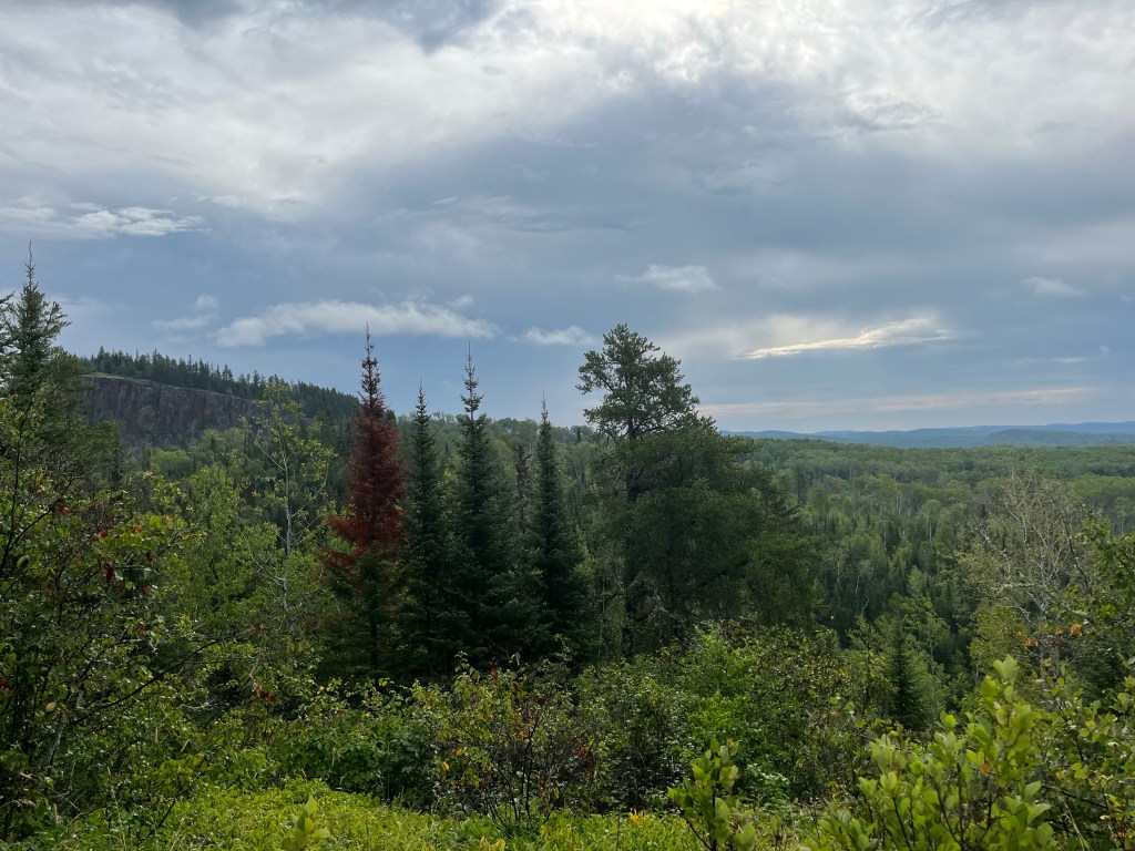
The center BWCA Wilderness section of the trail is the most remote, and less travelled, with over a dozen overlook points to enjoy.
- The trail is steep, narrow, and with rocks and roots that reminded us of the most rugged sections of the Superior Hiking Trail.
- There is more deadfall, overgrowth and brush to push through in this section, but the rewards of the vistas at the top make it all worth it.
- Slower hiking pace due to obstacles and brush, recommend 10 miles or less per day if you want to get to camp before dinner time.
- The Clearwater Lake segment was struck by a tornado in 2021 and was recently cleared to make it passable again. THANK YOU VOLUNTEERS!
- Despite trail clearing, this segment still requires a lot of over/under trees.
- The Daniels Lake and Long Portage section are typically flooded, so check the trail conditions page and be prepared for ankle to waist deep water when crossing the beaver dam and the adjoining trail.
- The Partridge Lake Campsite spur is passable, but can be challenging with sharp tree branches and a beaver dam/log crossing. Campsite is in a low lying area that can be wet and buggy.
- Be mindful of your bearings when re-routing around deadfalls as it can be easy to lose the trail at times. We wore safety whistles around our necks at all times during this trip in case we got separated but never had to use them.
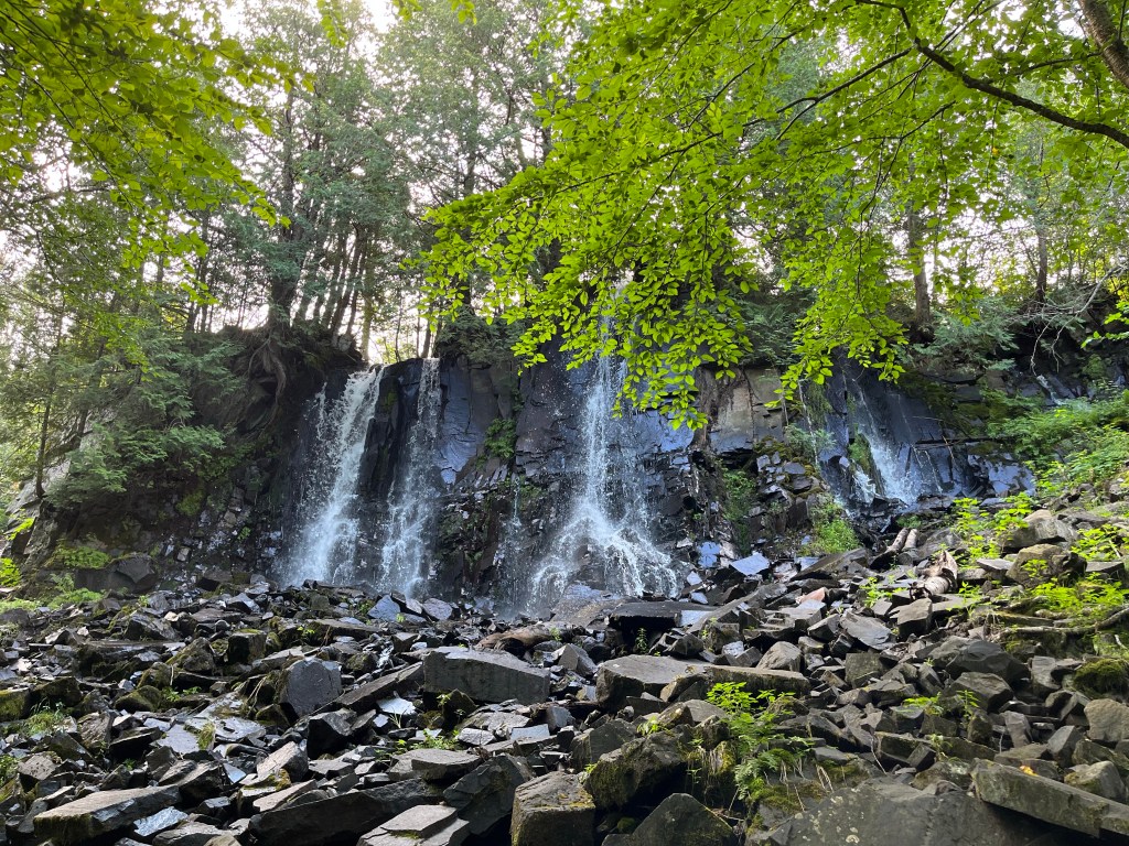
- Highlights are Rose Cliffs, Bridal Falls and Stairway Portage. We saw day hikers at the last two.
The Eastern or Pigeon River Section is the least used according to the guidebook and is primarily suited for backpacking as opposed to day hiking and winter sports.
- One foot in front of the other…
- The trail starts out well maintained as you exit the wilderness into the Superior National Forest, but the alders, ferns, grasses and thimbleberries are in full force this time of year, and it can be difficult to see your footing.
- Wet branches grazing you from head to toe may make you feel like you are in a car wash if it has recently rained…but on the upside, you’ll be clean!
- The Eastern entry to the BRT was a little challenging to find. It is overgrown and directly to the right of the trailhead sign. Heads up that there might be campers/vehicles parked in front of it, making it harder to spot.
- The trail continues through the McFarland State Forest Campground, through the thick forest and a large marshy, tall grass area before going up the hill to the 270 overlook.
- I did not make an exact location note, but the middle section of this trail near the Stump River and Portage Brook Rivers had several freshly downed pine trees that required navigating around. They were too thick to climb over or under.
- This section can also be very buggy and wet, and we found our raingear, sunglasses, trekking poles and headnets helpful protection in pushing through the wet brush/branches and hungry mosquitos.

History of the Trail
The Border Route Trail is a 65 mile footpath that began construction in 1972 and was completed in 1993. This pristine and rugged wilderness trail was the first long back-country trail to be built by volunteers and the first trail designed for non-motorized recreational use. 50 years later, this long trail is still maintained by volunteers, local resorts and offers and unique wilderness experience that gives hikers a glimpse into the untouched beauty of this magnificent region.

Trip Notes and Mileage
The following mileage and elevation data were provided by The Goat’s Garmin. All in all, we hiked 72.06 miles and gained a total of 10,444 ft and lost 11,436 ft. We hiked two half days and three full days, allowing for travel time to and from the trailhead. If we had to do it again, we probably would have done it in 6 days to allow for a slower hiking pace and a little more downtime at camp. I brought my field watercolor kit, but only used it once on our first night, the rest of the trip was a bit of a hustle…and required concentration and patience to navigate. But the views and mental clarity that comes with the basic rhythm of walking, eating, sleeping, walking, eating, sleeping… made this trip personally refining and strengthening.


Day 1: Gunflint to Loon Lake Campground | 9.19 miles
1,237 ft ascent | 1,237 ft descent
On Saturday, August 13 we headed up to Grand Marais at 7 am stopping at Cedar Coffee first for a giant breakfast burrito and coffee. We met Harriet at 9:45 and started the hour long shuttle ride up the Gunflint trail. Harriet is a legend in this area and was full of great stories all along the way. We started the hike at the magnetic rock trailhead and noted that the blueberries are plentiful in this section. You can read more about my paddling and painting trips to the Gunflint area here and here.

Weather conditions have been perfect and we are forecasted for 70’s and 50’s for highs and lows, with a 30% chance of rain on our last day. We stopped for a little water break on Gunflint lake and headed back on the trail.

Day one jitters evaporated as we walked deeper into the woods and enjoyed “fern surfing”, a term I read on the Border Route Facebook Page and immediately adopted. The green carpet was dotted with vibrant red velvet thimbleberries, ready for eating!


The trail is maintained yet overgrown, with occasional views of the lakes. For comparison, even the most remote Superior Hiking Trail and Isle Royale trails are much more established and travelled. We were happy to see the blue blazes and north country trail signage on the section, and expect that the middle section of the trail will not have that signage.


- Made it to camp by 4:30 after a buggy, muddy spur trail hike.
- Went for a swim in Loon Lake and it felt fantastic.
- Our campsite is right on the lake with easy water access, pine trees and a beautiful view
- Hung up a big clothesline to dry everything out.
- A swim and fresh, dry clothes at camp feels like a luxury.
- An early arrival at camp allowed for a little sunset watercolor painting-there would not be time for painting on the rest of the trip.
- Campsite was beautiful but heard the sound of cars on the Gunflint trail.

Day 2: Loon Lake to Partridge Lake Campground | 15.99 miles
2,179 ft ascent | 2,381 ft descent
- Left camp at 8am.
- Hiked to Bridal Falls for lunch. Beautiful waterfalls, and a slippery slide down the trail to the bottom.


- The trail is very brushy after Crab Lake, slow hiking. Shoulder high thimbleberries and face high alder brush.
- Lost track of how many times I twisted an ankle, stubbed my toe or bumped my head on branches.
- Tough day. Sore feet. Stopped at Topper lake for our 2nd break and to get our second wind.
- Arduous spur to Partridge Lake Campsite (after a long day). Evidence of past storms and volunteer trail clearing. Thank you volunteers!
- Watch your step at the beaver dam/roly-poly log crossing before camp. Kerplunk!
- Tent pads are small, hilly, and kind of swampy. Bug city.

Day 3: Partridge Lake to Clearwater Lake East Campground | 17.09 miles
2,762 ft ascent | 2,985 ft descent

- Left camp at 7:30/7:45
- 12 overlooks on the map
- 12 hours on the trail…
- up and down all day means AMAZING views!
- First stop, Rose Cliffs! Best view of the trail!
- Stairway Portage – there are 80 steps, totally worth the side trip. Great view of the waterfall and lake.
- Beaver pond water crossing at Daniels Lake. Wore our crocs to keep our shoes dry. Only knee deep.
- Baptized our dry shoes and socks 5 minutes later on the flooded “Long Trail Portage”
- Time got away from us today and the day was L O N G.


- Jungle gym-climbing over Clearwater tornado area, but you could see the incredible amount of work that was done in recent clearing.
- No time for painting today…or tomorrow…or the next day…
- Made it to camp at 7:30, right before sunset.


- Shared camp with two trail angel fishermen that were very kind and hospitable to us tired hikers.
- The fishermen were fun to talk to, and were very curious about the trail we were hiking, since they had only visited this area by boat. They started a fire, dried our shoes, fed us a second dinner of brats, potatoes & green beans. Offered to make us breakfast burritos and hot coffee in the morning!
- This lake shares access to Clearwater lodge and allows motorized boats.
- We stayed up and gabbed until 11:45 (way past hiker midnight) and slept fast for another big day on the trail!

Day 4: Clearwater Lake to McFarland Lake Campground | 16.24 miles
2,504 ft ascent | 2,825 ft descent
Left camp around eight after a delicious breakfast made by the fishermen. We weren’t sure what that think when we saw their camp set up and we kind of had nowhere else to go…since boaters are not required to share camp in the BWCA like most backpacking sites. These two fishing buddies and Dads showed us genuine kindness and it really brightened our spirits. Their camp was like an oasis or mirage after a long, tough day on the trail. A hearty breakfast of coffee, eggs, veggies and REAL CHEESE in a burrito got us ready for the day and put a big pep in our step! Thanks again guys!
The trail was challenging today, with lots of elevation, muggy damp forest, bugs, and brush slapping your face. Most of the views were obscured, but we did have a snack at one nice overlook. Our first decent break was at West Pike Lake, where we met two backpackers. They had just come off the Kekekabic trail and said it was in desperate need of clearing.


Right after they left, four otters popped their heads up one by one, right in front of us and made the cutest little squeaky sound! They peeped at us for a bit and then swam away… it was magical, surreal and wondered if I was dehydrated. A quick dip in the lake and full water bottles charged us up for our last leg for the day.
It’s funny what you think about on the trail….today I woke up with a dumb Matchbox 20 song in my head that stayed on repeat for 4 hours until I remembered that I brought a cheap pair of earbuds. I don’t usually hike with music for safety etc, but I was fading, stuck in my head, tripping over everything and getting crabby. So I popped one earbud in, hit play and the antidote to that irritating Matchbox 20 song was “Panama” by Van Halen! I don’t even remember how that song got in my phone… But I laughed at how happy that song made me feel in the moment and practically skipped up the hills and scissor kicked over the trees for the rest of the hike. Thank you, ridiculous David Lee Roth, flying through the air in spandex pants…thank you.
The last segment of today’s trail transitions from the Wilderness area to the Superior National Forest. The trees are thicker, the grass taller, and the section right before camp is generally pretty overgrown. Walking on the smooth dirt road to McFarland camp gave us a sensation similar to being in a boat all day and then hitting land…we felt floaty and disoriented walking on a flat and open surface, but were glad to be making our way to camp before sunset.
The McFarland campsite has a $12 per night fee, is first come first serve, has one pit toilet and has a lake for a water source with a nice dock. The campsite was generally quiet (despite one generator) and had a Sheriff Patrolling the grounds before nightfall.
One more sleep until the Eastern Terminus!
Day 5: McFarland Lake to Otter Tail Road | 13.55 miles
2,504 ft ascent | 2,825 ft descent
- Awake at 5, packed up and on the trail by 6:15.
- Walked around for a good while looking for the trail opening as it was so overgrown here- but we finally found our way in!
- Right after we started hiking, the rain started and so did the “green tunnel vision”. We had about 13 miles to hike before catching our 1 o’clock shuttle.
- This section of the trail was challenging due to slippery rocks, downed trees, high grass, brush and tree branches sweeping your face for miles.
- The rain and bugs kept us moving fast and we’re actually a blessing in hindsight. The section of the trail reminded me a lot of the Superior Hiking Trail and there were a couple of overlooks to reward all of the climbs but most of it was a green tunnel.
- Many large trees down in this area that were too thick to climb over and required navigating around. This took more time in concentration than we had anticipated. But the rain actually felt refreshing and cool compared to the warmer days on the trail. We wore our head nets and kept our trekking poles up for most for much of the hike to protect our faces from branches and other obstacles. I joked that we were in “shields up mode” with our hoods sunglasses and trekking poles and gloves up to push through the brush and overgrowth.
- No time for photos on this hike, but there are a few video clips to show conditions on our youtube video.
We hiked on, picking up our pace, watching the time to make sure that we were not lagging behind. We tried to take a short break but the bugs were so bad we just kept on hiking. We got to a section a mile or two before the 270 overlook that was waist high grass and looked like a wild animal trail… but it led us straight up to the top.

We hustled up the mountain as fast as we could to quickly sign the trail log, take a couple of pictures at the top and scoot our way back down to the end.

The End
A few minutes later, we heard distant car horn beeping… oh no, it’s Harriet!
We walked faster and I heard beeping again and I hollered as loud as I could
“HEEEERE WE ARRRRRRE HAAAAAAAAARRIEEEEEET! WEEEEEEEERE COOOOOOMINGGGGGGGGGGGG! WE’RE ONNN OUR WAAAAAAAAAAYYYYYY!”
I started to run. And I trotted down the rest of the mountain as fast as I could with my pack on (glad I lightened my load for this trip!). I shouted again, hoping she could hear us!
My endorphin filled brain was both convinced that we might miss our shuttle, and knew that Harriet wouldn’t have left us stranded in the middle of nowhere. I burst out of the woods completely drenched, flung my trekking poles in the air and shouted:
“WE MADE IT!!!!”
I ran to the wooden trail sign and slapped it with my hand, signed the trail log, threw my pack in the back and flopped my soaking wet body into the vinyl backseat of Harriet’s van.
The Goat and I had done it. Our most challenging hike ever…

Harriet congratulated us “girls”, told us that this trail was “a real feather in our cap” and that she’s accustomed to picking people up at the halfway point because it’s such a challenging trail. I’m glad she told us that afterward.
….dang, we actually did it…
This trail is serious business and we were prepared for that. We knew it would be difficult, but what we didn’t expect was miles and miles of pushing through brush and watching every single step your feet make. It’s not an impossible hike (obviously), but the stakes are higher on wilderness trail for many reasons. We felt privileged to be able to walk along a place where relatively few humans get to tread. It tested, refined, and strengthened us and we are so, so very grateful for this experience.

Final Thoughts
Together, The Goat and I completed 107 miles of the North Country Scenic Trail this year in two thru hikes: Pictured Rocks (MI) and the Border Route (MN). Pictured Rocks was one of the most beautiful, relaxing trails we’ve ever hiked, and the Border Route was a test of endurance, strength and resilience. Our Border Route trip connected our Superior Hiking Trail mileage to complete 375 miles of the MN Arrowhead (SHT+BRT=NCT)! We think that’s pretty cool! I’m so grateful for our friendship, her adventurous spirit and learn so much from her every time we share the trail. Thanks Goat!!
Huge thank you to the volunteers and staff for dreaming up this wilderness experience a half century ago and continuing to make this amazing trail the rare gem that it is!

Have you hiked the Border Route or other Boundary Waters Wilderness Trails? These trails require experience, navigation skills, and can easily fit the type 2 fun category. But they are SO WORTH IT! Check out this gear post and be sure to check out our youtube video!
Happy Trails!
~WP
Resources:
Border Route Trip video: Wandering Pine Youtube
Border Route Gear/Packing Video: Whats in my pack? 25 lb 5 Day Ultralight Gear list
Another beautiful BWCAW backpacking trail – The Sioux Hustler Trail
Border Route Association – needs volunteers!
Wandering Pine is reader-supported and some of our blog posts may contain affiliate links. Learn more here.
Thank you for your support!